
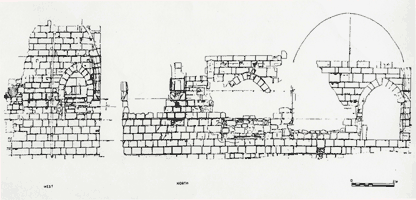
Architectural Evidence
The architectural evidence for the site of Saint-Jean-des-Vignes is very rich, and includes over a dozen standing or partially extant buildings. Foundations for more buildings have been discovered through excavation. Our approach to these buildings can be described as “anthropological” in that we regard them as part of the record of human activity on the site. We are curious about the functions that these structures served and about the ways in which they not only reflected human thoughts and actions, but in many ways served to shape them actively. We are also interested in the ways in which buildings were constructed on a living site, and in how they were shaped and changed across the centuries of their existence. Our analysis of them thus includes analysis of style, structure, construction and function.
Architectural Stratigraphy: From Recording to Reconstruction
The same principles of stratigraphy that have been applied to the excavated layers within an archaeological trench have also been applied to standing structures. Pioneered in England some thirty-five years ago by Harold Taylor and Warwick Rodwell, the principles of architectural stratigraphy – called “archéologie du bâti” in French—are now used widely throughout Europe. In this kind of analysis, the “deposition” of layers within a structure’s foundations and walls are analyzed to reveal the chronological sequence of the buildings’ construction.
Access Analysis
In an effort to examine the manipulation of space and movement through it, the technique of access analysis (space syntax analysis) has proven especially useful to a number of scholars. First developed by Bill Hillier and Julie Hanson as a design technique, access analysis has been adopted by archaeologists as an analytic tool.
Access analysis presumes an underlying spatial language that can be decoded through graphing of its grammar. It graphs each architectural space according to its “permeability,” or distance from the exterior. Each space and architectural volume is graphed as a node connected by a line to the other spaces with which it communicates directly. The resulting network of nodes and lines forms an “unjustified access map.” The “justified” map clarifies this network by presenting all connections which are made at a similar depth on the same level.
Mapping Access at Saint-Jean-des-Vignes
→ Perspectives for an Architecture of Solitude
→ Access map for the canonical community
The justified access map for Saint-Jean-des-Vignes shows all the connections existing among the spaces within the monastic enclosure. We see the ways in which access to the abbey is controlled by its fortified precinct, and in which entrance is permitted at only one point, the fortified gatehouse. Movement is then channeled through particular “checkpoints” such as the porter’s lodge and the refectory passage. The degree of remoteness from these points of entry and control can also be seen for spaces such as the dormitory and infirmary.
Access analysis has the advantage of being able to present both the totality of spaces and their access as a unified visual experience that privileges movement over buildings. Such analysis underscores the importance of zones that almost appear as “negative” space in a traditional plan. The great cloister at Saint-Jean is, as it is at nearly every monastery or convent, a physically open space. Access analysis underscores its position, however, as a major thoroughfare in human movement within the abbey.